
Chess Knight Move
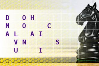
Find the country and its capital city, using the move of a chess knight. First letter is M. Length of words in solution: 7,8.Correct answers: 33
The first user who solved this task is Manguexa Wagle.
#brainteasers #wordpuzzles #chessknightmove

Kids in the back seat cause ac...
Kids in the back seat cause accidents; accidents in the back seat cause kids.
Never take life seriously. Nobody gets out alive, anyway.
An unbreakable toy is useful for breaking other toys.
Good health is merely the slowest possible rate at which one can die.
If FED EX and UPS were to merge, would they call it EF'D UP?
Everyone has a photographic memory; it's just that some of us are out of film.
How much deeper would the oceans be without sponges?
If quitters never win and winners never quit, what fool came up with, "Quit while your ahead"?!
If a deaf kid swears, does his mother wash his hands with soap?
If a turtle doesn't have a shell, is he homeless or naked?
What would a chair look like, if your knees bent the other way?
What do you do when you see an endangered animal eating an endangered plant?